Navigation

Mississippi Helping Mississippi coastal communities address weather and climate hazards.
Home

StormSmart MS

  • Home
    • About
      • Sitemap
      • Terms of Service
      • Contact Us
    • Community Rating System (CRS) Primer
      • CRS Credit Summary
    • No Adverse Impact (NAI)
      • NAI-level activities
    • Legal Introduction
      • Why You Should Manage Your Floodplains
      • The Four Types of Regulatory Takings
      • How NAI Can Help Your Community Avoid Lawsuits
    • Homeowners Handbook
  • Before the Storm
    • Identifying Hazards
      • Finding and Using Additional Hazard Information
      • Interpreting FIRMs and FIS Reports
      • Making Hazard Information Available and Accessible
      • Sharing Emergency Hazard Information
      • Understanding the Limitations of FIRMs and FIS reports
    • Planning
      • Creating a Community Master Plan
      • Creating a Multi-Hazard Mitigation Plan
      • Creating a Multi-Objective Management Plan
      • Creating Risk Mitigation Strategies
    • Regulations & Standards
      • Conducting Inspections of Lower-Area Enclosures
      • Considering Potential Future Conditions When Siting New Development
      • Creating Permanent No-Build Areas
      • Ensuring Local Regulations Allow Appropriate Development Techniques
      • Incorporating NFIP Requirements into Local Ordinances and Regulations
      • Keeping New Public Infrastructure Out of Hazard-Prone Areas
      • Passing Strict Zoning Ordinances and Regulations
      • Requiring Foundation/Building Certification
      • Using Freeboard to Elevate Structures Above Predicted Floodwaters
    • Mitigation
      • Acquiring Existing Structures
      • Non-Structural Shore Protection
      • ONLY AS A LAST RESORT: Flood and Erosion Control Structures
      • Relocating Existing Structures
      • Retrofitting Existing Structures
    • Infrastructure
      • Improving Construction and Design of Critical Facilities
      • Insuring Public Buildings
      • Keeping Roads and Utilities Out of Damage-Prone Areas
      • Maintaining an Inventory of Hazard Risks for All Public Property
      • Protecting Critical Access Routes
      • Siting Critical Facilities Out of Harm’s Way
    • Emergency Services
      • Creating a Post-Disaster Recovery Plan
      • Creating an Emergency Response Plan
      • Improving Disaster Response Coordination
      • Planning for Outside Help
    • Training & Outreach
      • Sources for Outreach Materials
      • General Hazard Awareness
      • Hazard Training for Local Officials
  • Homeowners Handbook
  • StormSmart Connect
  • Assessing Damage to Buildings
Return to Content

New Diagram of BP's Siphon Tube

Posted on May 24, 2010

BP-insertiontube.png
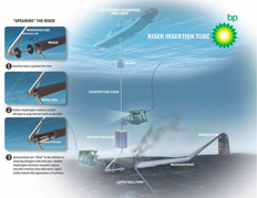
BP has released a new image of what’s going on a mile under the sea surface at the Deepwater Horizon site. Regrettably, it doesn’t appear to be working as well as they’d hoped.

About StormSmart admin

View all posts by StormSmart admin →

oil spill

Lots of Unknowns as Hurricane Season Closes in on Clean-Up Efforts
County Promotes More Precise Storm Surge Maps